


Mallorca Topo Maps
Descrição de Mallorca Topo Maps
+++ New Mapeamento GPS App +++
Fácil de usar Outdoor / offline aplicativo de navegação GPS com acesso aos melhores mapas topográficos e imagens aéreas para Mallorca.
++ Para usar recursos off-line PRO necessário! ++
Desligue o telefone Andoid / Tablet em um GPS ao ar livre para viagens para o sertão sem cobertura CELL. Esta aplicação dá-lhe opções de mapeamento semelhantes Como você poderia saber da Garmin ou Magellan GPS portáteis.
Incluído camadas mapa gratuito:
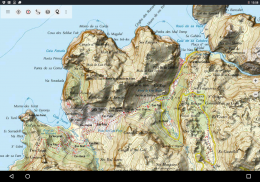
• Mallorca Topo Mapa: Mapa topográfico Nacional 1: 50.000 e 1: 25.000 (IGN MTN25 & MTN50)
• Mallorca Mapa Base: IGN Base de Topográfica Nacional 1: 25.000 (BTN25 & BCN25)
• Mallorca Imagery: alta resolução de imagens aéreas. Plano Nacional de Ortofotografía Aérea (PNOA)
• Cadastro Mapa: Cartografía catastral
• OpenStreetMaps: Estes mapas crowdsourced são uma adição muito útil para outras camadas do mapa. Contém muitas características únicas.
• OpenCycleMaps: Estes mapas são ideais para planejar passeios de bicicleta
• topográfico ESRI
• Imagens ESRI aéreos
• Mapa ESRI
• Mapa Google Road (acesso on-line)
• Imagens de satélite do Google (acesso on-line)
• Google Terrain Map (acesso on-line)
• Bing Road Map (acesso on-line)
• Imagens de Satélite Bing (acesso on-line)
• At Night Terra
• sobreposição Hillshading
Principais características ao ar livre-navegação:
• Criar e editar pontos de passagem
• GoTo Waypoint-navegação
• pista de gravação (com velocidade, elevação e perfil de precisão)
• Tripmaster com campos para odômetro, velocidade média, rolamento, altitude, etc.
• GPX / KML / KMZ Export
• Search (placenames, POIs, ruas)
• datafields personalizável no mapa e Tripmaster (por exemplo, velocidade, distância, Bússola, ...)
• partilhar pontos de passagem, trajectos ou itinerários (via email, WhatsApp, Dropbox, Facebook, ..)
• visualizar as coordenadas em Lat / Lon, UTM ou MGRS / USNG (Military Grade / US National Grid)
• Gravar e compartilhar faixas com estatísticas e perfil de elevação
• Rotação do mapa (Track Up & North Up)
• Obter Elevation por clique longa no mapa
• Repetir Pista
• e muitos mais ...
Disponível características Pro: (Pro recursos disponíveis através In App Purchase)
• uso off-line - sem cobertura celular necessária
• Fácil + rápido em massa-download de blocos de mapas para uso off-line (não para os mapas do Google e Bing)
• Criar e editar rotas
• Route-Navigation (Point-to-Point Navigation)
• GPX / KML / KMZ Import
• Os pontos de passagem ilimitada & Tracks
• Adicione Mapa outra Telha-Servidor
• No Ads
Use off-line:
Todos os blocos do mapa vistos são mantidos em cache. Para armazenar em cache grandes áreas que você precisa comprar Pro características.
Use este aplicativo de navegação para atividades ao ar livre como caminhadas, ciclismo, camping, escalada, passeios, esqui, canoagem, caça, passeios 4WD offroad ou busca e salvamento (SAR).
Adicione pontos de passagem personalizados em formato MGRS / USNG latitude / longitude, UTM ou com datum WGS84.
Import / Export / Share GPS-Paradas / Trilhas / Rotas em formato de Google Earth KML / KMZ GPX ou.
Pré-carregar dados de mapa gratuito para áreas sem serviço de celular (recurso Pro!).
Comentários e pedidos de funcionalidades para mallorcamaps@atlogis.com
Dê uma olhada em nossos outros aplicativos de navegação ao ar livre: https://play.google.com/store/search?q=atlogis
+++ Nós NÃO acompanhar quaisquer atividades do usuário ou coletar quaisquer dados do usuário! +++
Mallorca Topo Maps - Versão 7.7.2
(22-03-2025)Mallorca Topo Maps - Informação APK
Versão APK: 7.7.2Pacote: com.atlogis.mallorcaÚltima Versão de Mallorca Topo Maps
Outras versões


Apps na mesma categoria


